Title:
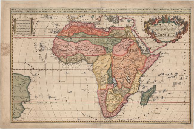
“Africa Divided According to the Extent of Its Principall Parts in Which Are Distinguished One from the Other the Empires, Monarchies, Kingdoms, States, and Peoples...”
Map Maker:
William Berry
This very rare map was created by William Berry ba... (full text available to subscribers)
| Item Detail |
| |
| |
MapMaker: |
William Berry
|
|
| |
| |
Subject: |
Africa |
|
| |
Period/Size: |
1680 / 22.3" x 34.7" (56.7 x 88.2 cm)
|
|
| |
Color: |
Colored
|
|
| |
Condition: |
(B+) Light soiling with paper watermarked "W" and a short repair in bottom right corner that has been professionally repaired. There is an old manuscript notation in left blank margin, and the margins have been professionally extended to accommodate fram (condition help) |
|
| |
Source: |
|
|
| |
References: |
Betz #124; Norwich #47; Shirley (BL Atlases) T.BERR-1a #35. |
|
| |
|
|
| Sales Information |
| |
| |
Price: |
|
|
| |
| |
Offered by: |
Old World Auctions |
|
| |
Catalog: |
Auction No. 159 - Antique Maps, Charts, Atlases & Globes (9324) |
|
| |
Lot/Item #: |
689 |
|
| |
| |
Date: |
09/2016
|
|
| |
| |
|
Antique Maps - Valuation and Pricing, Descriptions, Resources |
|
Home |
Information |
Search |
Register |
Contact Us |
Site Map
Americana Exchange, Inc. © 1999 - 2024 Americana Exchange, Inc.. All rights reserved.
OldMaps.com, the OldMaps.com logo and
AMPR are service marks or registered service marks of Americana Exchange, Inc..
|