Title:
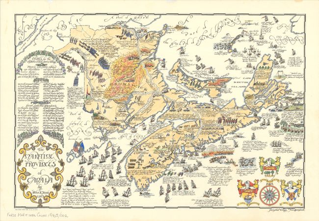
“The Maritime Provinces of Canada”
Map Maker:
Peter R. Furse
Peter R. Furse's rare map of New Brunswick,... (full text available to subscribers)
| Item Detail |
| |
| |
MapMaker: |
Peter R. Furse
|
|
| |
| |
Subject: |
Eastern Canada |
|
| |
Period/Size: |
1963 / 14.9" x 22.0" (37.9 x 55.9 cm)
|
|
| |
Color: |
Colored
|
|
| |
Condition: |
(A) On watermarked Superfine Linen Record 100% Canadian Rag by Rolland Paper Co. There are a couple minor spots in the map image and a few faint stains confined to the blank margins. (condition help) |
|
| |
Source: |
|
|
| |
References: |
Rumsey #15278. |
|
| |
|
|
| Sales Information |
| |
| |
Price: |
|
|
| |
| |
Offered by: |
Old World Auctions |
|
| |
Catalog: |
Auction No. 193 - Antique Maps, Charts, Atlases & Globes (9567) |
|
| |
Lot/Item #: |
106 |
|
| |
| |
Date: |
07/2023
|
|
| |
| |
|
Antique Maps - Valuation and Pricing, Descriptions, Resources |
|
Home |
Information |
Search |
Register |
Contact Us |
Site Map
Americana Exchange, Inc. © 1999 - 2024 Americana Exchange, Inc.. All rights reserved.
OldMaps.com, the OldMaps.com logo and
AMPR are service marks or registered service marks of Americana Exchange, Inc..
|